

Size Guide
Understanding Mylulusstore Sizing


Description
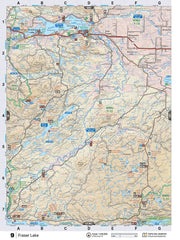
xThis recreation topographic map for the Fraser Lake area highlights all the logging roads, trails and recreation features for fishing, hunting, camping, hiking, mountain biking, canoeing, kayaking, backcountry skiing, wildlife viewing, ATVing, snowmobiling and more. No other map for the area provides you this level of recreational and topographic detail. New features include private land and labelled fish species plus countless new roads, trails and recreational Points of Interest. Covering Fraser Lake, Nechako Canyon Protected Area, Nechako River, Tahultzu Lake, Hallett Lake, Fort Fraser, Stellako, Engen, Tachick Lake, Paddle Lake and more, this map contains new features such as private land and labelled fish species. This 1:85,000 scale map covers 3,040 km2 (1,175 mi2), measuring 50 x 63.5 km (30 x 39.5 mi). This map also covers the following Wildlife Management Units: WMU 6-1 Skeena, WMU 6-4 Skeena, WMU 6-5 Skeena, WMU 7-11 Omineca, WMU 7-12 Omineca, WMU 7-13 Omineca. Fraser Lake - Northern BC is printed on demand at our office in Coquitlam (BC) and measures 61 x 94 cm (24 x 37 inches).

- Choosing a selection results in a full page refresh.