

Size Guide
Understanding Mylulusstore Sizing


Description
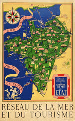
xOriginal vintage travel poster featuring a colourful Illustrated Map of the State Railways Sea and Tourism Network / Carte Illustre des Chemins de Fer de l'Etat Reseau de la Mer et du Tourisme by Lucien Boucher (1889-1971) marking routes from Dieppe to Bordeaux between town and city place names in decorative banners with images of notable and historic places of interest including the Eiffel Tower in Paris and chateaux, farming, trees, horses, sports, people swimming in the sea on the Atlantic Coast with sailing boats and ships following route lines to England and across the Atlantic Ocean towards Canada and America, a compass above with a flowing banner reading - 600 Plages 2000 kms de Cotes / 600 Beaches 2000km of Coast - leading down to a merman blowing a conch shell horn with the title text in a decorative box on the side and on the margin below. Fair condition, restored tears, restored folds, restored creasing, restored paper loss, staining, printing error, backed on linen.
- Choosing a selection results in a full page refresh.